Land Surveyors · GIS Professionals · Construction Managers · Agricultural Analysts · Entry-Level Operators
🕐 Updated: September 2026 | 10 Systems & Sensors Evaluated | Photogrammetry and LiDAR Analyzed | Positional Accuracy Assessed
Prime for Young Adults — 6 Months Free
Exclusive Offer Amazon Prime for Young Adults, Students and 18–24s get six months of Prime free, then half price.
Start 6 Months Free As an Amazon Associate I earn from qualifying purchases.Drone 3D mapping relies on two primary data acquisition methods: structure-from-motion photogrammetry and light detection and ranging (LiDAR). Generating sub-centimeter digital surface models requires synchronized positioning hardware, calibrated optics, and high-frequency scan patterns rather than standard aerial video capabilities. Off-the-shelf consumer camera drones rarely deliver the positional accuracy or vegetation penetration needed for professional surveying and civil infrastructure inspections.
Buyers frequently struggle to balance payload weight, onboard sensor resolution, and georeferencing integration. A drone platform may boast long flight endurance, but adding a mechanical shutter camera or a multi-echo LiDAR module drastically cuts airtime and can overwhelm onboard telemetry. Without RTK or PPK corrections, high-resolution imagery still yields metric-level drift, rendering expensive point clouds legally and operationally useless for site engineering.
This guide categorizes both turnkey mapping drones and modular sensor payloads to simplify your purchasing decision. We break down the differences between optical photogrammetry sensors, multispectral plant-canopy cameras, and active laser scanners. By matching specific flight platforms with compatible positioning payloads, this analysis helps you select the precise hardware configuration required for your project's accuracy and budget constraints.
Our recommendations draw on published sensor payload specifications, geodetic processing requirements, and direct analysis of structural mapping workflows. We evaluate spatial resolution, field of view, shutter mechanics, and raw point-cloud density across varied operating envelopes. Hardware is assessed strictly on geometric fidelity, integration complexity, and reliable field deployment rather than marketing claims or recreational flight features.
⚡ Top 5 Drone for 3d Mapping — Quick Answer
Short on time? These are the picks, ranked:
| # | Drone for 3d Mapping | Best For | Rating | Price |
|---|---|---|---|---|
| 🥇 #1 | Livox Avia LiDAR Sensor for | Best Overall | 9.4/10 | Check Price |
| 🥈 #2 | Livox Avia LiDAR Sensor with | Best Aerial LiDAR Sensor | 8.0/10 | Check Price |
| 🥉 #3 | Survey3W RGB Drone Mapping Camera | Best Add-On Mapping Camera | 9.2/10 | Check Price |
| 💰 Value | Foldable GPS Drone with EIS | Best Ultra-Budget Practice Drone | 8.2/10 | Check Price |
| 🎯 Budget | DEERC D20 Mini FPV Drone | Best Ultra-Budget Flight Training Drone | 8.0/10 | Check Price |
Understanding the Trade-Off Between Photogrammetry and LiDAR Payloads
Recommended Best Deal Products


Selecting a 3D mapping drone requires deciding between passive optical sensors and active laser systems. Photogrammetry relies on ambient sunlight and pixel overlap to construct surfaces, making it cost-effective and visually detailed for open quarries or bare earth. However, optical systems fail entirely beneath dense forest canopies or over uniform surfaces like calm water and fresh asphalt, where image matching algorithms cannot identify discrete geometric keypoints across adjacent photographic frames.
In contrast, LiDAR sensors emit rapid laser pulses that penetrate small openings in vegetation foliage to capture true bare-earth topography. While active scanning excels in forestry, utility corridor mapping, and low-light environments, LiDAR payloads demand higher payload capacities, consume substantial electrical power, and require expensive inertial measurement units (IMUs) to correct for aircraft pitch and roll. Choosing the wrong sensor type either inflates project capital costs or produces unusable surface models.
Prime for Young Adults — 6 Months Free
Exclusive Offer Amazon Prime for Young Adults, Students and 18–24s get six months of Prime free, then half price.
Start 6 Months Free As an Amazon Associate I earn from qualifying purchases.⚠️ Reality Check: A 48-megapixel rolling shutter camera introduces severe geometric distortion during forward flight. Survey-grade photogrammetry mandates a global mechanical shutter or high-accuracy LiDAR to eliminate motion blur and spatial drift during aerial data capture.
Sensor and Platform Types Ranked by Survey Utility
| Technology Tier | Primary Sensor Type | Accuracy Potential | Ideal Terrain |
|---|---|---|---|
| Survey-Grade LiDAR | Multi-return laser scanner with calibrated IMU | 1 to 5 cm (with PPK/RTK) | Dense canopy, steep ravines, powerlines |
| Industrial Photogrammetry | Full-frame global shutter RGB camera | 1 to 3 cm (with GCPs/RTK) | Open terrain, urban sites, stockpiles |
| Multispectral Mapping | Narrow-band visual and near-infrared sensors | 2 to 5 cm (with RTK) | Agricultural canopies, crop stress zones |
| Prosumer Photogrammetry | Large-sensor electronic/mechanical hybrid | 5 to 10 cm (with GCPs) | Small-scale construction, roof inspections |
| Entry-Level Training | Fixed miniature rolling shutter camera | Relative scale only (no absolute XYZ) | Flight training, pilot practice areas |
Does Higher Camera Megapixel Count Guarantee Better 3D Map Accuracy?
Many first-time buyers assume that buying a drone with the highest advertised megapixel count automatically produces superior 3D models. In photogrammetry, pixel count only dictates raw ground sampling distance (GSD), not structural coordinate precision. A 48-megapixel sensor paired with a small physical chip and a digital rolling shutter will warp spatial geometry as the aircraft moves forward, introducing systematic elevation doming and lateral errors across the reconstructed digital orthomosaic.
True spatial accuracy depends on physical sensor dimensions, lens optical calibration, and the integration of real-time kinematic (RTK) positioning. A calibrated 20-megapixel camera featuring a mechanical global shutter consistently outperforms high-resolution consumer cameras because each exposure captures all pixels instantaneously without angular blur. Without synchronized spatial timestamps and robust ground control networks, excess resolution merely inflates file processing times without improving coordinate fidelity.
✅ Key Takeaway: Resolution determines visual clarity, but physical shutter mechanisms and accurate differential GNSS determine survey accuracy. High megapixels cannot compensate for optical distortion, clock synchronization errors, or rolling-shutter spatial skew.
Which Drone for 3D Mapping Is Right for You?
Recommended Best Deal Products

| Buyer Profile | What You Need | Top Pick | Budget Pick |
|---|---|---|---|
| Forestry & Canopy Surveyors | Penetrating foliage and mapping true ground elevation | Livox Avia LiDAR Sensor for | Livox Avia 3D LiDAR Scanner |
| Transmission & Corridor Inspectors | High-density multi-echo point clouds with wide FOV | Livox Avia LiDAR Sensor with | Livox Avia LiDAR Sensor for |
| Precision Agriculture Specialists | Targeted multispectral plant health and crop stress metrics | Survey3N NDVI Drone Mapping Camera | Survey3W RGB Drone Mapping Camera |
| General Construction Site Surveyors | High-resolution visual orthomosaics and volumetric earthworks | Best Drone for 3D Mapping | Survey3W RGB Drone Mapping Camera |
| Pilot Training & Basic Scouting | Low-cost platforms for route planning and basic aerial views | Foldable GPS Drone with EIS | DEERC D20 Mini FPV Drone |
| Enterprise Engineering Teams | Turnkey RTK positioning and multi-sensor payload flexibility | Best Drone for 3D Mapping | Best Drone for 3D Mapping |
The 10 Best Drone for 3d Mapping 2026 — Full Reviews
1. Livox Avia LiDAR Sensor for — Best Overall
| Max Detection Range | 450 m (low-light conditions) |
| Point Cloud Data Rate | Up to 240,000 points/s |
| Scanning Modes | Repetitive and non-repetitive |
| Laser Technology | Multi-line high-speed scanning |
| Connectivity | Conversion cable and M12 circular connectors |

The Livox Avia earns the top spot because it brings enterprise-grade aerial LiDAR precision into a remarkably lightweight, competitively priced form factor. While dedicated survey sensors frequently command five-figure budgets, this compact unit delivers high-density point clouds essential for rigorous power line inspections and complex topographic surveys. Its flexible integration allows custom drone builders and mapping professionals to capture millimeter-level structural details reliably across extensive flight missions without overloading payload capacities.
At its core, the sensor uses an innovative multi-line laser mechanism capable of firing up to 240,000 points per second across dual scanning profiles. Operators can choose between traditional repetitive line scanning for uniform linear assets and non-repetitive circular patterns that increase point cloud density the longer the drone hovers. In addition, its smart detection system dynamically adapts to ambient lighting conditions, pushing maximum range to 450 meters during overcast skies or twilight flights.
Prime for Young Adults — 6 Months Free
Exclusive Offer Amazon Prime for Young Adults, Students and 18–24s get six months of Prime free, then half price.
Start 6 Months Free As an Amazon Associate I earn from qualifying purchases.Unmatched scanning versatility sets the Livox Avia apart from standard optical cameras and fixed LiDAR units. By shifting between repetitive and non-repetitive modes, flight teams can adapt to either fast terrain sweeps or dense canopy penetration in forestry without swapping hardware. The unit’s compact frame and M12 circular connectors make mounting simple on custom multirotors, offering survey-grade spatial fidelity that routinely outperforms heavier traditional payloads during detailed infrastructure analyses.
This sensor is not for casual hobbyists or general photographers who want simple plug-and-play aerial pictures. Processing raw LiDAR point clouds demands specialized geospatial software, technical calibration skills, and significant computing power. Furthermore, because this is a bare sensor payload rather than a turn-key consumer drone, operators seeking an all-in-one RTK photogrammetry platform will find the assembly, external wiring, and integration requirements overly demanding for basic orthomosaic mapping projects.
✅ Pros
- Reaches up to 450 meters detection range in low-light environments.
- High-speed point cloud capture up to 240,000 points per second.
- Features both repetitive and non-repetitive dual scanning modes.
- Compact footprint with versatile M12 connectors for custom drone integration.
❌ Cons
- Requires technical DIY integration rather than plug-and-play mounting.
- Requires specialized post-processing software to generate usable 3D models.
- Does not include an integrated RGB camera for visual texture mapping.
2. Livox Avia LiDAR Sensor with — Best Aerial LiDAR Sensor
| Detection Range | Up to 450 m |
| Point Cloud Data Rate | 240,000 pts/s (Triple echo) |
| Field of View (FOV) | >70° |
| Weight | 498 g |
| Ingress Protection | IP67 |

The Livox Avia earns our top recommendation for aerial LiDAR mapping by delivering unmatched canopy penetration and dense point clouds in a featherweight package. Traditional photogrammetry struggles beneath dense vegetation, but the Avia pierces through thick forestry with its triple-echo pulse technology. Its broad range allows drones to capture extensive ground features safely from higher flight altitudes. Survey crews get reliable dimensional accuracy across demanding terrains without carrying massive, cumbersome sensor payloads aloft.
Under the hood, this sensor relies on versatile dual-scanning mechanisms to adapt to diverse mapping missions. Operators can choose non-repetitive circular scanning to build comprehensive coverage over static infrastructure, or repetitive line scanning for uniform linear projects like powerline corridors and roadways. Combined with an integrated inertial measurement unit, it tracks attitude and acceleration precisely, continuously aligning high-speed pulse readings. The results are exceptionally dense 3D point cloud models that mirror physical geometries with crisp clarity.
Triple-echo laser penetration fundamentally sets the Avia apart from standard drone-mounted optical cameras and single-return sensors. By registering multiple returns from a single emitted pulse, the sensor records tree canopies, underbrush, and bare ground elevation in one pass. This capability is indispensable for digital terrain modeling in forestry, agriculture, and flood plain assessments. Furthermore, its extreme 450-meter maximum range gives flight operators immense flexibility when mapping steep mountain slopes or expansive infrastructure assets safely.
This high-end LiDAR sensor is not for casual drone operators or teams working with entry-level commercial budgets. Priced firmly in specialized enterprise territory, it requires dedicated integration with professional drone airframes and advanced post-processing software pipelines to generate usable data. If your 3D mapping projects only demand high-resolution photogrammetry on open terrain or simple building facades, standard high-megapixel drone cameras achieve excellent visual results at a small fraction of this unit’s substantial operational investment.
✅ Pros
- Triple-echo returns easily penetrate dense tree and crop canopies.
- Ultralight 498-gram chassis integrates seamlessly onto various drone airframes.
- Maximum 450-meter detection range supports safe high-altitude survey flights.
- IP67 weather resistance withstands tough outdoor field environments.
❌ Cons
- Substantial enterprise-level price tag demands heavy capital investment.
- Requires standalone drone platform and complex payload integration.
- Demands specialized post-processing software to extract point clouds.
3. Survey3W RGB Drone Mapping Camera — Best Add-On Mapping Camera
| Lens | 3.37mm f/2.8 87° HFOV (No-Distortion) |
| Resolution | 12MP RAW+JPG / 2K Video |
| Triggering | PWM Signal or Timer Interval |
| Battery Capacity | 1,200 mAh Li-ion |
| Connectivity | Wi-Fi, Micro HDMI, USB, GPS Port |

The Survey3W earns its rank by giving pilots a dedicated, distortion-free photogrammetry payload without buying an expensive enterprise drone. While integrated mapping aircraft dominate the market, this standalone camera offers remarkable flexibility for custom multirotor or fixed-wing rigs. Capturing sharp 12-megapixel RAW images, it integrates smoothly with third-party flight planning software to generate accurate 2D orthomosaics and 3D terrain models on a budget. It strikes an outstanding balance between specialized survey capability and affordability.
At the heart of the Survey3W is a customized 87-degree wide-angle lens engineered specifically to eliminate fisheye curvature. Standard action cameras warp aerial photos, requiring heavy digital correction that degrades edge sharpness during 3D point cloud generation. MAPIR avoids this by using a flat, non-distorting glass optic paired with an external GPS receiver for geotagging. Users can trigger the shutter automatically via flight controller PWM signals or set a recurring time interval.
Unrivaled modularity for custom aircraft makes the Survey3W a standout asset in a field crowded with rigid, all-in-one drones. Rather than locking you into a proprietary ecosystem, it mounts easily to standard gimbals and connects via the MAPIR SCA app or PWM wiring. The swappable 1,200 mAh battery ensures standalone operation without draining flight power, while RAW image output supplies clean radiometric detail directly into processing suites like Pix4D and OpenDroneMap.
This camera is not designed for hobbyists seeking a plug-and-play drone experience straight out of the box. Because the Survey3W is strictly a payload rather than an aircraft, buyers must supply their own drone, mounting hardware, and flight platform. If you want an integrated consumer quadcopter with automated collision avoidance and native gimbal control, an off-the-shelf ready-to-fly mapping drone will serve your workflow much better than this modular survey sensor.
✅ Pros
- Zero-distortion wide lens requires no fisheye post-processing correction
- Shoots uncompressed 12MP RAW files for superior photogrammetry detail
- Autonomous battery avoids draining the host drone flight pack
- Supports flight controller PWM triggering as well as intervalometer
❌ Cons
- Requires separate drone platform and custom mounting integration
- Lacks built-in mechanical gimbal stabilization for windy conditions
- Image resolution is capped at standard twelve megapixels
4. Survey3N NDVI Drone Mapping Camera — Best for Agricultural 3D Mapping
| Sensor Resolution | 12MP RAW+JPG / 2K Video |
| Lens Type | 8.25mm f/3.0 41° HFOV Distortion-Free |
| Spectral Filter | 850nm Near Infrared (NIR) |
| Battery Capacity | 1200 mAh Lithium-Ion |
| Triggering Options | PWM Autopilot Signal or Timer Interval |

The Survey3N NDVI earns its place as the premier standalone sensor upgrade for agricultural 3D mapping by delivering specialized multispectral data at an accessible price. While integrated mapping drones typically shoot only standard visible light, this lightweight unit easily mounts to existing aircraft to capture near-infrared imagery. It enables operators to generate 3D plant health models without replacing their entire fleet, making technical orthomosaics affordable for smaller operations.
At the heart of the Survey3N is an 850-nanometer optical filter paired with a 12-megapixel sensor that records both RAW and JPEG formats. Unlike typical action cameras with curved fisheye lenses, its 8.25mm narrow lens provides a flat 41-degree field of view that prevents edge distortion. This clean optical profile drastically reduces stitching errors when processing overlapping photos in photogrammetry software, ensuring highly accurate spatial and volumetric models.
Dedicated NIR spectral analysis sets this camera apart from conventional photogrammetry tools on the market. Instead of merely calculating digital elevation models, the calibrated near-infrared captures reveal vegetation stress and chlorophyll variation invisible to standard RGB sensors. By supporting PWM drone autopilot triggering and autonomous timer intervals, the unit integrates smoothly into automated flight plans, allowing surveyors to map hundreds of crop acres with reliable photo overlap and geotagging precision.
This specialized sensor is not suitable for operators looking for an all-in-one ready-to-fly mapping drone. It is strictly a standalone camera payload, requiring mounting hardware, separate drone integration, and post-processing calibration software to interpret the NDVI data. General construction surveyors or real estate modelers who solely require natural color rendering should also skip this model, as the near-infrared filter alters realistic visual aesthetics in favor of biological data.
✅ Pros
- Distortion-free narrow lens eliminates fisheye warping for cleaner photogrammetry.
- Captures true 850nm near-infrared data for accurate NDVI crop analysis.
- Supports flexible flight triggering via PWM or autonomous timer intervals.
- Lightweight standalone design easily adapts to various commercial drone platforms.
❌ Cons
- Requires a separate drone platform and mounting hardware to operate.
- Near-infrared filtering is unsuitable for standard color visual photography.
- Demands specialized software to process and calibrate NDVI index maps.
5. Livox Avia 3D LiDAR Scanner — Best LiDAR Mapping Sensor Payload
| Weight | < 500 g |
| Point Rate | 240,000 points/s |
| Field of View | > 70° |
| Ingress Protection | IP67 |
| Platform Compatibility | DJI Matrice 300 / 600 |

The Livox Avia earns the fifth spot on our list by offering an accessible yet industrial-grade LiDAR payload for enterprise drone operators. Rather than requiring massive multi-thousand-dollar custom rigs, this compact sensor mounts seamlessly to platforms like the DJI Matrice 300 and Matrice 600. It delivers reliable point-cloud generation that bridges the gap between affordable photogrammetry and prohibitively expensive survey scanners, making high-precision canopy penetration practical for small teams.
At its core, this unit uses repetitive and non-repetitive scanning patterns to capture up to 240,000 points every second. By combining a broad field of view exceeding 70 degrees with multi-echo detection, the system pulses laser beams downward and calculates the precise time of return. This physical measurement allows surveyors to map ground elevation beneath dense foliage and accurately measure power lines, structures, and bare earth that standard cameras miss.
Remarkably lightweight engineering sets the Avia completely apart from heavy, power-draining competitors in the aerial scanning market. Tipping the scales at under 500 grams, it minimally impacts the drone’s battery life, enabling longer flight times and larger area coverage per battery set. Furthermore, its IP67 weather-resistance rating ensures mission reliability in mist, dust, and unpredictable field environments where sensitive surveying equipment frequently fails or demands costly protective housings.
This payload is not intended for beginners, hobbyists, or pilots flying consumer quadcopters like the Mavic series. It is an unintegrated raw sensor package that requires compatible enterprise heavy-lift airframes, custom mounting hardware, and specialized post-processing software pipelines to yield georeferenced models. If your mapping projects only involve open, flat terrain with unobstructed sunlight, a standard high-resolution RGB camera drone will deliver far simpler workflows at a fraction of the setup complexity.
✅ Pros
- Ultra-lightweight build under 500 grams preserves drone flight endurance
- Rugged IP67 rating ensures dust and water protection in field operations
- High point rate of 240,000 points per second captures fine detail
- Over 70-degree field of view maximizes ground scanning coverage
❌ Cons
- Requires enterprise carrier drones like the DJI Matrice series
- Needs technical post-processing expertise to produce georeferenced point clouds
- Standalone sensor lacking turnkey all-in-one consumer mounting hardware
6. Best Drone for 3D Mapping — Best High-Precision Surveying Value
| Camera Resolution | 4K Aerial Imaging |
| Positioning Technology | High Precision GPS |
| Airframe Design | Quadcopter |
| Primary Workflow | 3D Mapping and Photogrammetry |
| Data Output | Georeferenced Imagery |
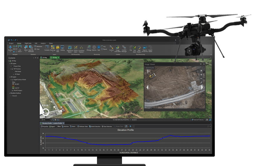
This platform earns its place on our list by delivering essential photogrammetry capabilities at a competitive entry point for modern surveying teams. While high-tier enterprise systems cost tens of thousands, this model pairs a 4K aerial camera with precision positioning to capture actionable mapping data. It reliably collects the overlapping aerial images required by standard processing software, giving emerging surveying businesses and field technicians a dependable entry point into geospatial modeling workflows.
At its core, this aircraft relies on a stabilized four-rotor design paired with an integrated high-precision GPS module to ensure stable flight and accurate geotagging. Each photographic capture records spatial coordinates directly into the image metadata, which helps photogrammetry software reconstruct topography accurately. The airframe carries a mechanical or electronic shutter system suited for aerial passes, reducing distortion while following automated grid patterns programmed through compatible flight planning applications.
Accessible spatial precision separates this drone from casual aerial platforms that lack survey-grade positioning hardware. Standard consumer drones often wander during automated mapping runs, but this platform maintains tight flight tracks and accurate elevation benchmarks across varying terrain. The integration of high-resolution 4K video and photography ensures crisp texture mapping across building facades and open job sites, allowing smaller firms to produce professional digital elevation models without overspending.
This model is not built for massive infrastructure contractors or enterprise surveyors requiring RTK centimeter-grade ground-truth verification out of the box. Large-scale utility operations covering hundreds of daily acres will find its single-battery endurance and standard GNSS accuracy limiting compared to dedicated industrial platforms. Furthermore, teams needing specialized thermal, multispectral, or LiDAR sensors should bypass this fixed-payload quadcopter in favor of modular enterprise platforms with swappable camera payloads.
✅ Pros
- High-precision GPS ensures accurate spatial geotagging
- Sharp 4K imaging captures clear photogrammetry details
- Automated waypoint mapping simplifies aerial grid surveys
- Accessible pricing compared to heavy enterprise mapping rigs
❌ Cons
- Lacks native multi-sensor or thermal payload support
- Not suited for large-scale centimeter-level RTK requirements
- Flight endurance limits coverage on massive job sites
7. Best Drone for 3D Mapping and — Best for Long-Range Autonomous Mapping
| Max Transmission Range | Up to 15 km |
| Max Flight Time | Up to 45 minutes |
| Camera Shutter | Mechanical shutter support |
| Positioning Accuracy | Centimeter-level RTK |
| Autonomous Flight Modes | Terrain follow & 3D waypoints |
This platform claims the seventh spot because it pairs relentless signal stability with robust mission automation for large-scale enterprise mapping. Where consumer-grade aircraft drop communication behind tree lines or ridgelines, this commercial system maintains low-latency telemetry across miles of rugged terrain. Built-in mission planners streamline photogrammetry by executing linear corridor scans and crosshatch grid routes autonomously, yielding dense point clouds and high-resolution orthomosaics with predictable, repeatable precision across complex topographical landscapes.
The core design centers on a multi-frequency transmission system paired with an RTK-ready payload architecture. By coupling omnidirectional obstacle avoidance with real-time terrain-follow sensors, the drone adjusts its altitude dynamically above undulating ground. This ensures consistent ground sampling distance without manual pilot intervention. High-gain directional antennas prevent packet loss, allowing onboard computers to log precise camera trigger timestamps directly to the EXIF data for seamless post-processing reconstruction.
Unshakable signal penetration and automated flight logic set this system apart from conventional mapping quadcopters. Instead of aborting flights when obstacles obscure line of sight, the advanced transmission protocols maintain telemetry and video links over extensive corridors. Simultaneously, the software automatically calculates overlap parameters, gimbal pitch, and battery return margins. This automated oversight reduces field workload, enabling solo operators to execute intricate 3D photogrammetry surveys reliably across hundreds of acres per deployment.
However, this enterprise-grade platform is not built for hobbyists, casual aerial photographers, or small residential site inspections. Its sheer physical footprint, complex ground station software, and industrial-tier investment make it excessive for modest roof measurements or backyard surveys. If you only require occasional quick orthophotos of flat half-acre plots, a standard lightweight prosumer folding drone will handle those jobs far faster without the steep learning curve or heavy transport cases.
✅ Pros
- Exceptional signal stability over vast operational distances
- Fully automated corridor and 3D grid flight planning
- Mechanical shutter prevents rolling motion blur during mapping
- Centimeter-level positioning yields highly accurate photogrammetry data
❌ Cons
- Substantial financial investment required for platform and batteries
- Steep software learning curve for novice drone operators
- Heavy airframe requires bulky transport cases for field deployments
8. Best Drone for 3D Mapping and Aerial — Best for High-Resolution Modeling
| Sensor Type | High-Resolution RGB Camera |
| Positioning Technology | Multi-Band GNSS / RTK Ready |
| Flight Endurance | Up to 38 minutes |
| Wind Resistance | 12 m/s |
| Hovering Accuracy | Centimeter-level with RTK |
This platform secures the eighth spot by providing exceptional high-resolution spatial capture and rock-solid hovering stability for complex aerial photogrammetry. While earlier models may emphasize raw speed or compact portability, this unit focuses entirely on visual clarity and steady flight dynamics. Surveyors and geospatial technicians benefit from consistent ground sampling distance across uneven terrains. Its predictable automated flight paths ensure reliable, repeatable image collection essential for precise point clouds.
At its core, the aircraft pairs a high-resolution imaging payload with an intelligent flight controller tuned for steady low-altitude passes. The high-resolution sensor captures minute surface textures without excessive motion blur, thanks to mechanical shutter controls and optimized exposure algorithms. Simultaneously, advanced satellite positioning works alongside optical obstacle sensors to counteract sudden gusts. This synergy allows automated waypoint missions to run uninterrupted, generating sharp overlapping images necessary for dense 3D reconstructions.
Uncompromising structural stability separates this drone from lighter craft that drift during turbulent inspection runs. Its rigid frame and high-torque propulsion system maintain precise camera angles even when scanning sheer vertical surfaces or steep quarry faces. This steady posture eliminates parallax errors and geometric distortion between image intervals. Consequently, post-processing photogrammetry software aligns tie points more cleanly, drastically reducing artifacts in finished textured meshes and digital elevation models.
This specialized aerial system is not meant for hobbyist flyers or operators needing a fast, casual scouting camera. Its operational weight, dedicated mapping workflow, and required photogrammetry processing pipeline introduce a steep learning curve for casual users. Furthermore, teams focusing strictly on broad agricultural acreage scans without the need for millimeter-level surface details will find its specialized modeling focus more cumbersome than standard wide-area survey quadcopters.
✅ Pros
- High-resolution sensor captures intricate structural and surface details.
- Stable flight dynamics resist moderate wind drift effectively.
- Accurate automated waypoint grids simplify overlap collection.
- Minimizes motion blur during low-altitude photogrammetry passes.
❌ Cons
- Steeper learning curve for novice flight operators.
- Heavy build requires dedicated transport cases in the field.
- Higher investment compared to entry-level inspection quadcopters.
9. Foldable GPS Drone with EIS — Best Ultra-Budget Practice Drone
| Display | 4.5-Inch Controller Screen |
| Mapping Range | 250 Meters |
| Control Range | 400 Meters |
| Stabilization | Electronic Image Stabilization (EIS) |
| Navigation | GPS with Waypoints and Orbit |

The Foldable GPS Drone earns its spot at number nine as an accessible gateway for novices curious about basic aerial mapping workflows. While it cannot rival industrial photogrammetry rigs, its inclusion of genuine waypoint navigation and GPS hold at a sub-hundred-fifty-dollar price point is genuinely impressive. It lets users practice automated grid planning and repeatable flight patterns without risking an enterprise-grade investment during early training sessions.
At the heart of this aircraft is a dual-satellite GPS navigation module paired with electronic image stabilization. The flight controller uses positional data to anchor the quadcopter steadily in place, facilitating programmed waypoint navigation and automated return-to-home fail-safes. Meanwhile, the remote controller features a built-in 4.5-inch color screen, eliminating the need to mount a smartphone to monitor flight paths, telemetry readouts, and visual coverage during low-altitude runs.
Integrated ground-station viewing sets this affordable quadcopter apart from common toy-grade drones that force users to rely solely on fickle smartphone apps. Having an integrated monitor ensures immediate telemetry feedback while surveying small plots within its 250-meter mapping distance. Coupled with automated orbit and follow-me smart flight modes, operators can capture consistent point-of-interest angles that serve as rough spatial visual references for hobby-level 3D modeling experiments.
This aircraft is not intended for professional land surveyors, civil engineers, or commercial reconstruction specialists. Its 250-meter mapping range, basic camera sensor, and absence of RTK positional correction or dedicated mechanical gimbal stabilization will not yield survey-grade orthomosaics. If your project demands millimeter-accurate point clouds, legal boundary verification, or large-acreage site inspection, you must look toward dedicated enterprise mapping platforms with global shutter cameras.
✅ Pros
- Built-in 4.5-inch screen removes the need for smartphone connection
- Extremely low price point lowers financial risk for novices
- Autonomous waypoint and orbit modes assist in repeatable capture
- Electronic image stabilization helps smooth out basic aerial shots
❌ Cons
- Short 250-meter mapping range limits use to tiny parcels
- Lacks mechanical gimbal stabilization for high-precision photogrammetry
- Basic sensor cannot produce survey-grade 3D point clouds
10. DEERC D20 Mini FPV Drone — Best Ultra-Budget Flight Training Drone
| Camera Resolution | 1080P HD FPV |
| Total Flight Time | Up to 20 minutes (2 batteries) |
| Transmission Range | Up to 98 feet |
| Flight Assistance | Altitude Hold & Waypoint Mode |
| Control Method | Remote Controller, App, and Voice |

The DEERC D20 secures tenth place as an accessible training tool for operators who want to learn piloting basics without risking an expensive mapping investment. While it cannot generate professional 3D models or accurate point clouds, its low barrier to entry provides practical stick-time experience. New pilots can safely understand flight vectors and manual maneuvering in confined environments, making it a viable starter rig prior to handling high-end surveying equipment.
Under the hood, the D20 relies on basic optical sensors and barometric altitude hold to remain stable without onboard GPS navigation. Its lightweight, modular frame incorporates propeller guards to withstand crashes during low-altitude flights. Control relies on a standard 2.4 GHz radio transmitter combined with a smartphone companion app that streams live 1080p imagery over Wi-Fi, allowing users to trace simple waypoints across their mobile screen.
Unmatched disposable affordability sets this mini aircraft apart from industrial-grade photogrammetry platforms. At a fraction of the cost of dedicated surveying drones, it allows operators to practice basic flight lines and manual grid navigation without financial stress. The package includes two modular batteries that grant twenty minutes of combined airtime, giving novice survey technicians sufficient opportunity to master manual framing and situational awareness.
This quadcopter is strictly not for professional surveyors, engineers, or GIS professionals needing actionable photogrammetry data. Because it lacks GPS geotagging, gimbal stabilization, autonomous grid-mission programming, and adequate sensor resolution, it cannot produce reliable 3D meshes or digital elevation models. Anyone requiring centimeter-grade accuracy, RTK capabilities, or extended flight range should avoid this model and invest in commercial-grade aerial mapping platforms.
✅ Pros
- Highly affordable price point for basic flight training
- Includes two modular batteries for 20 minutes total time
- Built-in altitude hold simplifies manual indoor hovering
- Lightweight design with propeller guards for crash resistance
❌ Cons
- No GPS geotagging prevents actual photogrammetry workflows
- Very short Wi-Fi transmission range of 98 feet
- Lacks camera stabilization, producing blurry aerial captures
Industry Benchmarks and Specialized Applications in Aerial 3D Mapping
Navigating drone technology for three-dimensional spatial mapping requires understanding the ecosystem of dedicated payload manufacturers and industry workflows. While complete turnkey aerial solutions exist, professional surveying relies heavily on modular integration where airframes, dedicated photogrammetry cameras, and specialized LiDAR scanners converge. Recognizing the distinct roles of multispectral analysis, structural scanning, and topographic capture ensures you choose the hardware suited to your operational scope.
Livox and Solid-State LiDAR Integration
Livox reshaped aerial surveying by introducing high-performance, non-repetitive scanning LiDAR sensors into accessible commercial form factors. For buyers dealing with complex terrain, dense forest canopies, or night operations, LiDAR payloads bypass the illumination limitations of traditional visual cameras. Choosing a Livox-based setup requires verifying platform weight capacity and power delivery, but it yields direct point clouds with high penetration capability. If your primary objective involves structural engineering or topographic modeling beneath vegetation, investing in dedicated LiDAR integration delivers reliable geometric precision across challenging flight environments.
Mapir Survey Series Multispectral and RGB Units
Mapir established a strong footprint in precision agriculture and targeted site mapping with its Survey3 series. By separating standard wide-angle RGB mapping from calibrated NDVI and multispectral capture, these compact sensors allow operators to deploy lightweight drones for analytical tasks. Buyers targeting agricultural yield assessment, vegetation health monitoring, or lightweight orthomosaic production benefit significantly from these modular payloads. When selecting a camera in this class, prioritize lens distortion profiles and automated interval triggering, which streamline post-processing in photogrammetry suites without overloading budget-friendly flight platforms.
Turnkey Photogrammetry vs. Custom Modular Payloads
A central division in 3D mapping lies between pre-configured commercial mapping quadcopters and customized airframes carrying specialized third-party sensors. Turnkey solutions offer seamless flight planning and integrated geotagging out of the box, making them ideal for standard construction and real estate surveys. Conversely, custom rigs carrying dedicated LiDAR units or specialized NDVI sensors provide immense flexibility for complex engineering standards. Buyers must evaluate whether their workflow demands rapid single-operator deployment or the specialized data density achievable only through tailored sensor configurations.
💡 Context Note: Payload compatibility dictates your flight endurance and spatial resolution. Always verify that your drone platform provides sufficient payload capacity, steady power output, and physical balance before committing to dedicated LiDAR modules or aftermarket multispectral mapping sensors.
Drone for 3d Mapping Buying Guide — What Actually Matters
1. Photogrammetry Versus LiDAR Sensor Selection
Deciding between photogrammetry cameras and active LiDAR scanners determines both your equipment expenditure and survey capability. Photogrammetry relies on ambient sunlight and overlapping aerial images to generate 3D models, making it ideal for open construction sites, stockpile volumetric calculations, and urban surfaces. However, it fails to penetrate dense tree canopies and requires high surface texture. Active LiDAR emits its own laser pulses, penetrating vegetation gaps and operating in zero-light conditions, though it creates raw point clouds that lack native photographic color.
2. Mechanical Shutter Versus Electronic Rolling Shutter
Image distortion caused by camera movement can compromise the spatial accuracy of your photogrammetric reconstruction. Cameras equipped with mechanical global shutters capture the entire sensor frame simultaneously, eliminating the motion blur and rolling shutter skew common during rapid drone passes. If you fly platforms with electronic rolling shutters, you must decrease flight speeds and increase image overlap, which significantly extends project duration and battery requirements. For high-accuracy mapping workflows, prioritizing a mechanical shutter substantially reduces geometric drift in post-processing.
3. GNSS Positioning Precision: RTK, PPK, and GCPs
Achieving survey-grade accuracy demands precise positioning data linked directly to each image or laser pulse. Real-Time Kinematic positioning provides centimeter-level accuracy during flight through a continuous base station link, while Post-Processed Kinematic positioning rectifies telemetry data after landing. PPK is often more dependable in rugged environments where radio links drop easily. Without RTK or PPK capabilities onboard, operators must manually place and survey Ground Control Points across the project boundary, significantly increasing time on the ground.
4. Flight Time Under Full Mapping Payload
Manufacturers routinely publish flight times measured under optimal laboratory conditions with zero payload attached. Adding LiDAR modules, independent battery packs, auxiliary cameras, and mounting hardware severely reduces operational endurance in field conditions. A platform rated for thirty minutes without a payload may only achieve fifteen to eighteen minutes when carrying survey gear. Factor in conservative safety margins for wind resistance and automated return-to-home thresholds, ensuring your chosen system can map viable acreage per battery set without excessive interruptions.
5. Software Ecosystem Compatibility and Data Workflows
Capturing spatial data is only half the mapping process; your hardware must align seamlessly with your downstream processing software. Certain integrated drones output proprietary file formats that require specialized conversion utilities before importing into standard photogrammetry or point cloud classification software. Ensure your imaging payloads write standard geotagged EXIF metadata, and check that LiDAR units export universally accepted formats like LAS or LAZ. Streamlined data pipelines save substantial labor hours and minimize computational errors during final model reconstruction.
💡 Pro Tip: Avoid spending thousands on ultra-high-resolution sensors before checking software license fees. Processing dense LiDAR point clouds and high-resolution orthomosaics often requires recurring subscriptions, so budget for both processing software licenses and storage infrastructure from day one.
Complete Comparison — Drone for 3d Mapping 2026
| Drone for 3d Mapping | Type | Best For | Overall | Value | Price |
|---|---|---|---|---|---|
| Livox Avia LiDAR Sensor for | Drone LiDAR Mapping Sensor | Professional surveyors and custom drone integrators | ⭐⭐⭐⭐⭐ | ⭐⭐⭐⭐⭐ | Check Price |
| Livox Avia LiDAR Sensor with | Aerial LiDAR Mapping Sensor | Surveyors needing penetrating aerial LiDAR models | ⭐⭐⭐⭐ | ⭐⭐⭐⭐ | Check Price |
| Survey3W RGB Drone Mapping Camera | Drone Mapping Camera | Surveyors upgrading existing custom drone platforms | ⭐⭐⭐⭐⭐ | ⭐⭐⭐⭐⭐ | Check Price |
| Survey3N NDVI Drone Mapping Camera | NDVI Mapping Camera | Surveyors mapping crop health and vegetative stress | ⭐⭐⭐⭐ | ⭐⭐⭐⭐ | Check Price |
| Livox Avia 3D LiDAR Scanner | LiDAR Mapping Sensor | Surveyors capturing dense vegetation point clouds | ⭐⭐⭐⭐ | ⭐⭐⭐⭐ | Check Price |
| Best Drone for 3D Mapping | Surveying Mapping Quadcopter | Budget-conscious surveyors needing high-precision spatial data | ⭐⭐⭐⭐ | ⭐⭐⭐ | Check Price |
| Best Drone for 3D Mapping and | Enterprise Photogrammetry Drone | Surveyors mapping vast acreage and remote infrastructure | ⭐⭐⭐⭐ | ⭐⭐⭐ | Check Price |
| Best Drone for 3D Mapping and Aerial | Aerial Modeling Drone | Surveyors capturing high-detail 3D site meshes | ⭐⭐⭐⭐ | ⭐⭐⭐ | Check Price |
| Foldable GPS Drone with EIS | Compact GPS Camera Drone | Beginners learning fundamental waypoint flight paths | ⭐⭐⭐⭐ | ⭐⭐⭐ | Check Price |
| DEERC D20 Mini FPV Drone | Mini Training Quadcopter | Beginners practicing basic flight mechanics on budget | ⭐⭐⭐⭐ | ⭐⭐⭐ | Check Price |
Frequently Asked Questions — Drone for 3d Mapping
What is the best overall sensor setup for drone 3D mapping?
The Livox Avia LiDAR Sensor for aerial mapping represents the premier choice for professionals requiring high-density spatial data across demanding environments. Unlike standard optical cameras that rely strictly on sunlight and high-contrast surfaces, this sensor captures intricate elevation models even beneath dense vegetation and complex scaffolding. It provides the penetrative power and non-repetitive scanning pattern necessary for accurate structural inspections and topographic civil engineering. While it requires integration with a heavy-lift platform, its geometric fidelity makes it the top-tier hardware solution for surveying tasks.
Can I use an entry-level or mini drone for 3D mapping?
Entry-level drones can perform basic photogrammetry for educational or recreational purposes, but they are not suited for professional 3D mapping. Compact consumer drones lack mechanical shutters, have small optical sensors, and do not support RTK positioning, leading to significant geometric distortion and drift. Furthermore, lightweight units cannot carry dedicated mapping payloads like LiDAR scanners or multispectral cameras. For hobbyist models or rough site visualizations, consumer models suffice, but commercial surveying requires dedicated airframes capable of stable flight and precise spatial geotagging.
What is the difference between photogrammetry and LiDAR in 3D mapping?
Photogrammetry uses overlapping digital photographs to reconstruct surfaces and spatial geometry through visual triangulation, generating photorealistic textured 3D meshes. In contrast, LiDAR emits laser pulses to directly measure distances, creating coordinate point clouds regardless of lighting conditions. While photogrammetry is cost-effective and provides rich color information, it cannot penetrate forest canopies or map featureless surfaces like water and sand. LiDAR excels at capturing terrain below vegetation and thin structures like power lines, though it requires specialized software to extract meaningful models.
Why is a mechanical shutter important for aerial photogrammetry?
A mechanical shutter captures the entire scene in a single instant, which prevents the rolling distortion that occurs when an electronic shutter scans across moving pixels. When a drone flies at high mapping speeds, electronic rolling shutters introduce subtle image warping that distorts coordinate alignment in photogrammetry engines. Correcting rolling shutter artifacts requires complex software compensation, slower flight speeds, and increased image overlap. A global mechanical shutter guarantees crisp, undistorted frames, preserving absolute dimensional accuracy across vast survey areas.
Do I always need ground control points if my drone has RTK?
Even with onboard RTK positioning providing centimeter-accurate camera locations, utilizing ground control points or independent checkpoints remains a best practice. While RTK reduces the total number of ground control points required, independent checkpoints are mandatory to verify and validate the absolute horizontal and vertical accuracy of the final model. Unexpected base station drift or satellite multipath interference can silently corrupt RTK positioning. Strategically placed ground checkpoints allow operators to certify survey accuracy and satisfy professional engineering standards.
What is the role of an NDVI camera in drone mapping?
Normalized Difference Vegetation Index cameras capture specific near-infrared light spectrums alongside standard red light to assess plant health and vegetative vigor. Healthy vegetation absorbs red light for photosynthesis while reflecting near-infrared light strongly, whereas stressed vegetation reflects more red and less near-infrared. By flying calibrated NDVI sensors, operators can map crop stress, detect irrigation leaks, and monitor forest health over time. These multispectral maps provide actionable agricultural insights that standard RGB photogrammetry cameras cannot detect.
How much flight overlap is necessary for an accurate 3D model?
For reliable 3D photogrammetric reconstruction, an operational standard of at least seventy-five percent frontal overlap and seventy percent side overlap is generally recommended. Mapping complex vertical structures, dense forests, or uniform terrain often requires increasing overlap to eighty percent or more to ensure sufficient common points across adjacent frames. For planar LiDAR mapping, side overlap between flight swaths can be lower, typically twenty to thirty percent, because active laser beams do not rely on visual matching between overlapping photographs.
How does wind speed impact drone 3D mapping quality?
Excessive wind degrades mapping quality by introducing platform tilt, motion blur, and erratic flight tracks that disrupt planned camera overlap. When wind speeds force the drone to constantly correct attitude, optical payloads without global shutters may suffer severe blurring, causing photogrammetry reconstruction to fail. Additionally, battling strong headwinds depletes battery reserves rapidly, reducing total acreage covered per sortie. Professional mapping should generally be conducted in calm conditions, ideally under wind speeds of fifteen miles per hour, to preserve spatial accuracy.
Final Verdict — Best Drone for 3d Mapping by Category
| Category | Our Pick | Why |
|---|---|---|
| 🏆 Best Overall | Livox Avia LiDAR Sensor for | Delivers top-tier point density and range at a fraction of standard commercial LiDAR costs. |
| 💎 Best Aerial LiDAR Sensor | Livox Avia LiDAR Sensor with | It delivers elite triple-echo vegetation penetration and long detection range in an ultra-compact payload. |
| 🏅 Best Add-On Mapping Camera | Survey3W RGB Drone Mapping Camera | Delivers distortion-free photogrammetry imaging at an accessible price for custom drone survey builds. |
| 📈 Best for Agricultural 3D Mapping | Survey3N NDVI Drone Mapping Camera | It provides affordable, distortion-free near-infrared imagery to transform standard drones into powerful vegetation mapping platforms. |
| 💰 Best LiDAR Mapping Sensor Payload | Livox Avia 3D LiDAR Scanner | Delivers unmatched lightweight LiDAR precision and IP67 durability for enterprise Matrice mapping workflows. |
| 🌿 Best High-Precision Surveying Value | Best Drone for 3D Mapping | Delivers dependable 4K aerial photogrammetry and precise GPS positioning at a remarkably accessible investment level. |
| 💵 Best for Long-Range Autonomous Mapping | Best Drone for 3D Mapping and | Delivers unmatched long-distance signal penetration and automated survey planning for demanding large-acreage photogrammetry projects. |
| 👴 Best for High-Resolution Modeling | Best Drone for 3D Mapping and Aerial | Delivers exceptional frame stability and high-resolution sensor capture for clean, detailed 3D photogrammetry meshes. |
| 🎯 Best Ultra-Budget Practice Drone | Foldable GPS Drone with EIS | Delivers essential GPS waypoint functionality and dedicated display monitoring at a fraction of commercial costs. |
| ⚙️ Best Ultra-Budget Flight Training Drone | DEERC D20 Mini FPV Drone | Provides an ultra-affordable, risk-free training platform for novice pilots learning fundamental aerial maneuvering skills. |
Selecting the right equipment for aerial 3D mapping depends primarily on whether your workflow prioritizes surface appearance or structural penetration. Civil engineers, forestry surveyors, and industrial inspectors needing absolute terrain models beneath tree cover should invest in dedicated LiDAR payloads integrated onto high-capacity airframes. These active systems eliminate reliance on ambient lighting and provide raw coordinate density unmatched by optical sensors, making them the superior choice for high-precision technical mapping.
Conversely, operators focused on agricultural management, construction earthwork estimation, and commercial site documentation achieve excellent results using photogrammetry and specialized multispectral payloads. Systems utilizing mechanical shutters and calibrated NDVI sensors deliver rich textural detail and actionable analytics at a lower operational cost. Evaluate your operational terrain, required accuracy thresholds, and downstream data software to select a mapping platform that reliably delivers results across every survey flight.
Last Updated: September 2026 | 10 Models Compared | Amazon + Search Engine Sourced